01 · SCORE
One verdict, your boat
A 22′ center console and a 14′ skiff do not share a bad day. Each launch site gets one GO / CAUTION / NO-GO planning score against the vessel and thresholds you set.
See how →
Marine planning bulletinUS coastal waters
The boat ramp reality check: wind, swell, tide, and the rulebook for your launch site — one page, one verdict, before the trailer leaves the driveway.
Funny name. Serious planning.
86 CURATED SITES · 18 REGIONS · NO CREDIT CARD
LIVE— scored from the latest snapshot, 28 SEP 2026 · 11:35Z · sign up for your own sites.
86
CURATED LAUNCH SITES
18
REGIONS COVERED
78
SPECIES IN THE RULEBOOK
3
MAP LAYERS ON EVERY SITE
Fed by NOAA buoys · NWS forecasts · CO-OPS tides — snapshots refreshed every 90 minutes
03/The conditions page
37.4955°N · 122.4850°W
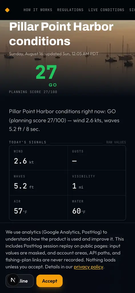
The conditions page for your launch site gathers wind and gusts, swell height and period, tides, water temperature, marine warnings, solunar windows, and the applicable state rules — and turns them into a score for your vessel.
What you're looking at here isn't a mockup. It's the app itself, captured from the Pillar Point Harbor conditions page.
Fig. 1 — Conditions page · Pillar Point Harbor
Real app capture · 2026-08-16
04/The score
0–100 · tuned to your vessel
Every score is a weighted sum over the signals that matter at your launch site — wind, waves, warnings, visibility, lightning. Each one shows its raw value, its severity, and its weight, so the number is never a black box.
LIVE· Signal audit — Pillar Point Harbor
Live signal audit — scored from the latest snapshot, 28 SEP 2026 · 11:35Z see the full brief →
05/Timing
Solunar + tide windows · per site, per day
A GO day still has better hours than others. Each launch site gets its solunar major and minor windows plus the tide cycle for the day — computed from the site's coordinates, not a generic regional table.
AS OF 05:02 LOCAL · Pillar Point Harbor
ASTRONOMY ENGINE · CO-OPS
BEST WINDOW REMAINING TODAY
MAJOR · 13:39–15:39
lower transit
SUNRISE 07:03 · SUNSET 18:58 · SITE LOCAL TIME
BITE WINDOWS ARE GUIDANCE, NOT SAFETY ADVICE.
06/The trip loop
From driveway to dock and back
T.01
Pick a launch site, a date, and a vessel profile. Your trip keeps its condition guidance attached — nothing to rebuild the morning of.
T.02
Saved trips are re-checked against the latest public data until you cast off. No refreshing, no rebuilding the forecast by hand.
T.03
When a monitored trip's status flips — GO to NO-GO, or back — you get the push. You adjust plans, not discover problems at the ramp.
T.04
Share a float plan link with your crew before launch: site, window, vessel, and expected return — readable with one tap, no account needed.
T.05
Set an expected return and a shore contact. Come back and check in — or, past your window by 2 hours, we escalate once: push to you, email to them.
AFTER THE TRIP
Each past trip from the last 60 days becomes a draft entry automatically. Every entry remembers the day — conditions, craft, and miles — with room for species, counts, sizes, and photos.
Watch the trip back on the map: your GPS track with speed, time-interpolated position, and a scrubber. Tracks are kept 30 days — longer once saved to a logbook entry.
07/Pricing
Free forever · Pro billed yearly
$0 forever
$39.99/yr · $3.33/mo billed annually
Pro: 7-day fishable calendar — forward days use wind and weather only; waves and water conditions are not forecast. Billing handled by Stripe; cancel anytime from Settings, keep Pro through the paid period. Prefer to pay as you go? Pro is also $4.99/mo billed monthly, same features.
08/FAQ
Straight answers
The short version of the manual. Anything else — ask us directly.
A 0–100 planning number for one launch site on one day, computed from public conditions against the thresholds you set for your vessel. 0–39 renders GO, 40–59 CAUTION, 60–100 NO-GO. It is a planning input, not a guarantee — you are always the captain. READ HELP ↗
Public feeds: NOAA and NWS for wind, waves, tides, visibility, warnings, and forecast grids; official state-agency pages for fishing regulations. Every rule row links to its source, and the catalog re-checks source pages on a weekly schedule. READ HELP ↗
Two mechanisms. A signal past your vessel's threshold — say 4 ft waves on a kayak profile — drags the composite toward NO-GO, and several breaches together land it there. Veto signals (marine warnings, lightning risk) can cap a day at CAUTION or NO-GO outright, whatever the rest of the board says. READ HELP ↗
The 7-day fishable calendar: forward days compare across your saved sites using wind and weather only — waves and water conditions are not forecast. Pro also surfaces the next day that fits your thresholds, so you can plan around it. $39.99/yr, billed annually.
A curated catalog of US coastal launch sites, plus cited fishing regulations across 23 states and territories. You can also add your own site — pick a state and the rulebook resolves for it.
It gets monitored. Until you cast off, the trip re-checks against the latest data; if its status flips, you get a push alert. Before launch you can share a float plan link, and after launch the check-in clock runs — pass your expected return by 2 hours and we escalate once: push to you, email to your shore contact. READ HELP ↗
Yes — it is a web app that installs to your home screen from the browser and keeps working on a flaky signal. Native mobile apps are in testing and will carry the same saved sites, trips, and alerts.
09/Last Call
No card required
Free to start, no credit card required. Add your launch sites and review the available planning guidance.